
Introduction
Transboundary aquifers (TBAs) between Mexico and the United States are vital yet underrecognized components of regional water security. Shared groundwater systems sustain the domestic water use of at least a dozen sister communities along the U.S.-Mexico border. Climate change stress, population growth-driven water demand, and growing surface water scarcity have intensified reliance on TBAs. It is estimated that between 7 to 9 million people depend on TBAs alone to fulfill their domestic and agricultural needs in the U.S.-Mexico border region. Yet, unlike surface water, which is governed by the 1944 U.S.-Mexico Water Treaty and its 332 Minutes issued by the International Boundary and Water Commission (IBWC), TBAs lack formal recognition or regulation at the binational level.
Drawing on over a decade of interdisciplinary research, this brief sheds light on the most valuable and strategic resource of the U.S.-Mexico border region: its shared groundwater systems. The analysis details the hydrogeological, legal, and institutional dimensions of these transboundary aquifers. It identifies key governance challenges and provides policy recommendations to strengthen binational cooperation, data harmonization, and inclusive resource management.
Strategic Importance of Transboundary Aquifers
Transboundary aquifers are vital sources of freshwater for communities, ecosystems, and economies across the world. Globally, groundwater accounts for approximately 97% of the planet’s nonfrozen freshwater, and nearly 50% of the world’s population relies on it daily for drinking water. Over 40% of irrigated food production depends on groundwater, making it indispensable for food security and climate resilience. Yet, groundwater does not respect political borders: as of 2021, 468 transboundary aquifers and aquifer systems have been identified worldwide, under nearly every nation.
Despite their scale and significance, only a fraction of TBAs are governed by formal cooperative frameworks. Between the United States and Mexico, recent research has advanced this global conversation by expanding the inventory of U.S.-Mexico transboundary aquifers from 11 to 72 hydrogeological units. Although these aquifers — including Hueco Bolson, Mesilla, Edwards Aquifer System, Carrizo-Wilcox, and Allende-Piedras Negras in the Texas-Mexico border — support significant populations along the border, they remain outside the scope of the 1944 Water Treaty.
What is Transboundariness?
Recognizing the strategic value of groundwater as a shared resource across borders, the “transboundariness” concept — developed in 2018 — reframes aquifers as sociopolitical systems. These systems are shaped not only by their physical features but by legal pluralism, institutional asymmetries, socioeconomic variables and uneven data access.
Transboundariness is defined as the strategic value of an aquifer that happens to be located within the boundaries of two or more countries. It involves socioeconomic and political variables and community values that provide a more integrative strategic assessment of a shared transboundary resource. It highlights more clearly that without coordinated governance across borders, these shared resources face mounting risks of depletion, contamination, and inequitable access. Challenges mirrored across continents — from the Mekong to the Dinaric Karst — involve water scarcity and environmental degradation that ultimately undermine the national security of affected countries.
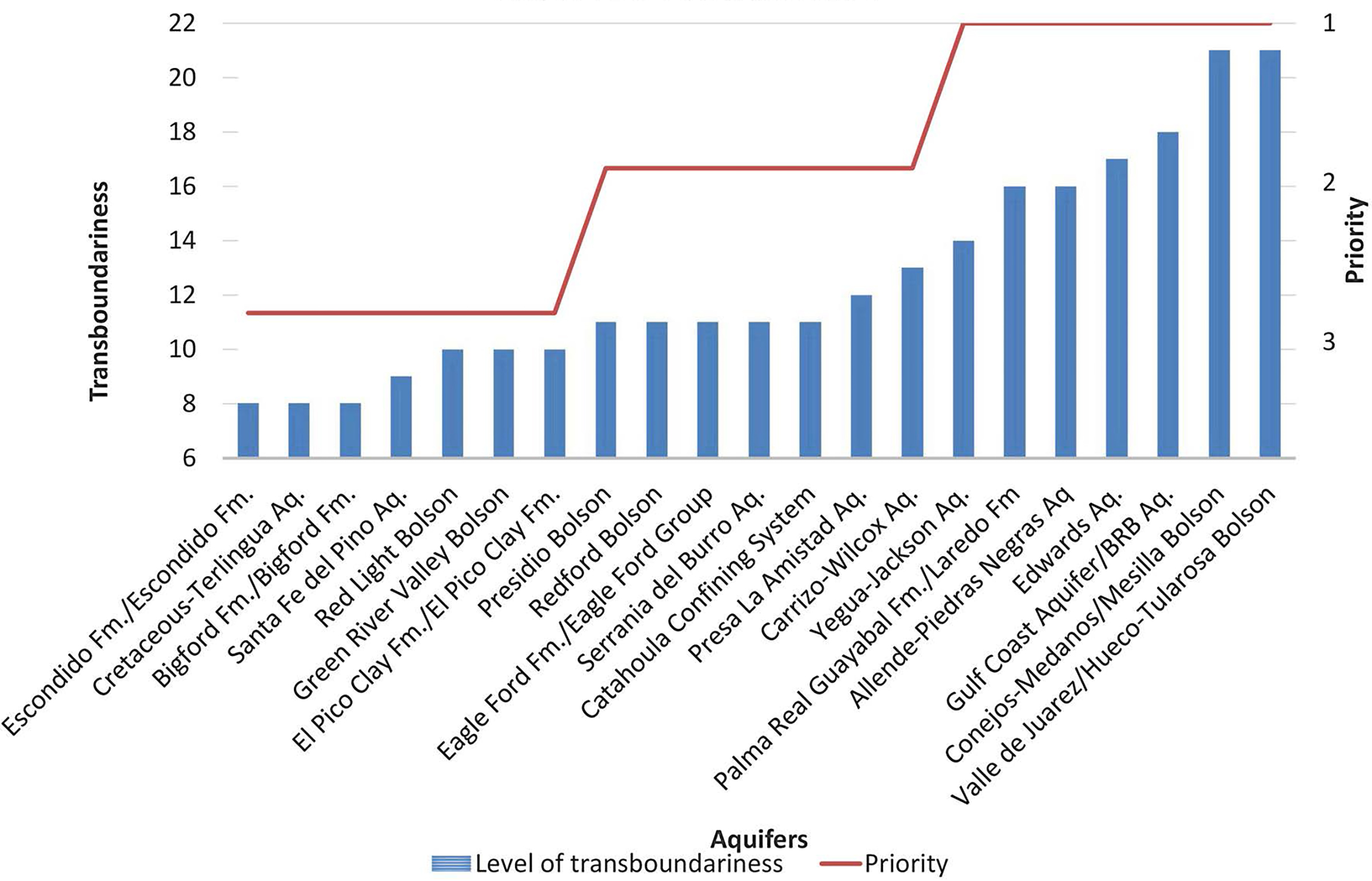
For the U.S.-Mexico border, the following TBAs have been identified as the most significant aquifers due to their high level of transboundariness and are therefore considered top priority (Figure 1):
- Hueco and Mesilla Bolsons.
- Gulf Coast Aquifer
- Edwards Aquifer System.
- Allende Piedras Negras.
- Palma Real/Laredo.
- Carrizo Wilcox.
- Presa La Amistad.
Figure 1 — Priority Aquifers According to the Transboundariness Approach
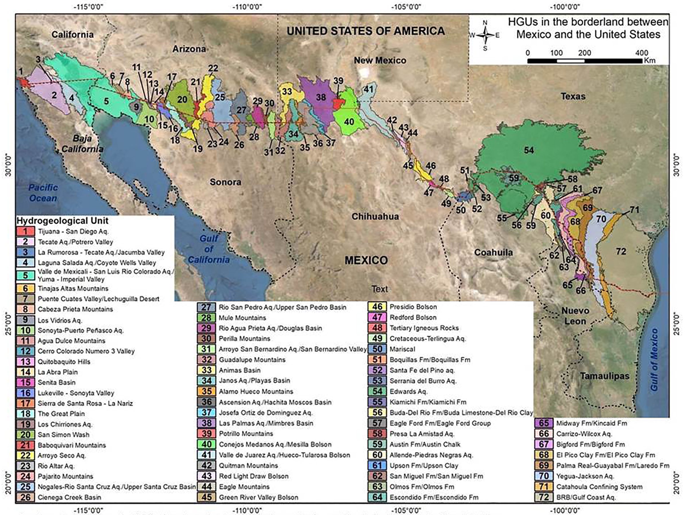
Scientific Advances: Mapping the Border’s Hidden Waters
Formal binational efforts initially identified 11 TBAs almost two decades ago. In 2018, Sánchez et al. identified 72 hydrogeological units, with 28 showing strong aquifer potential. Priority aquifers based on the initial and most recent studies include:
- Hueco Bolson (Texas-Chihuahua).
- Mesilla Bolson (New Mexico-Texas-Chihuahua).
- San Pedro and Santa Cruz (Arizona-Sonora).
- Allende-Piedras Negras (Coahuila-Texas).
- Yuma/Río Colorado (California, Arizona-Baja California, Sonora).
These findings and research advances have informed binational and international mapping and delineation, binational modeling efforts, and decision-support tools used by agencies and stakeholders in the border region (Figure 2).
Figure 2 — Transboundary Aquifers Between the U.S and Mexico: The Complete Map
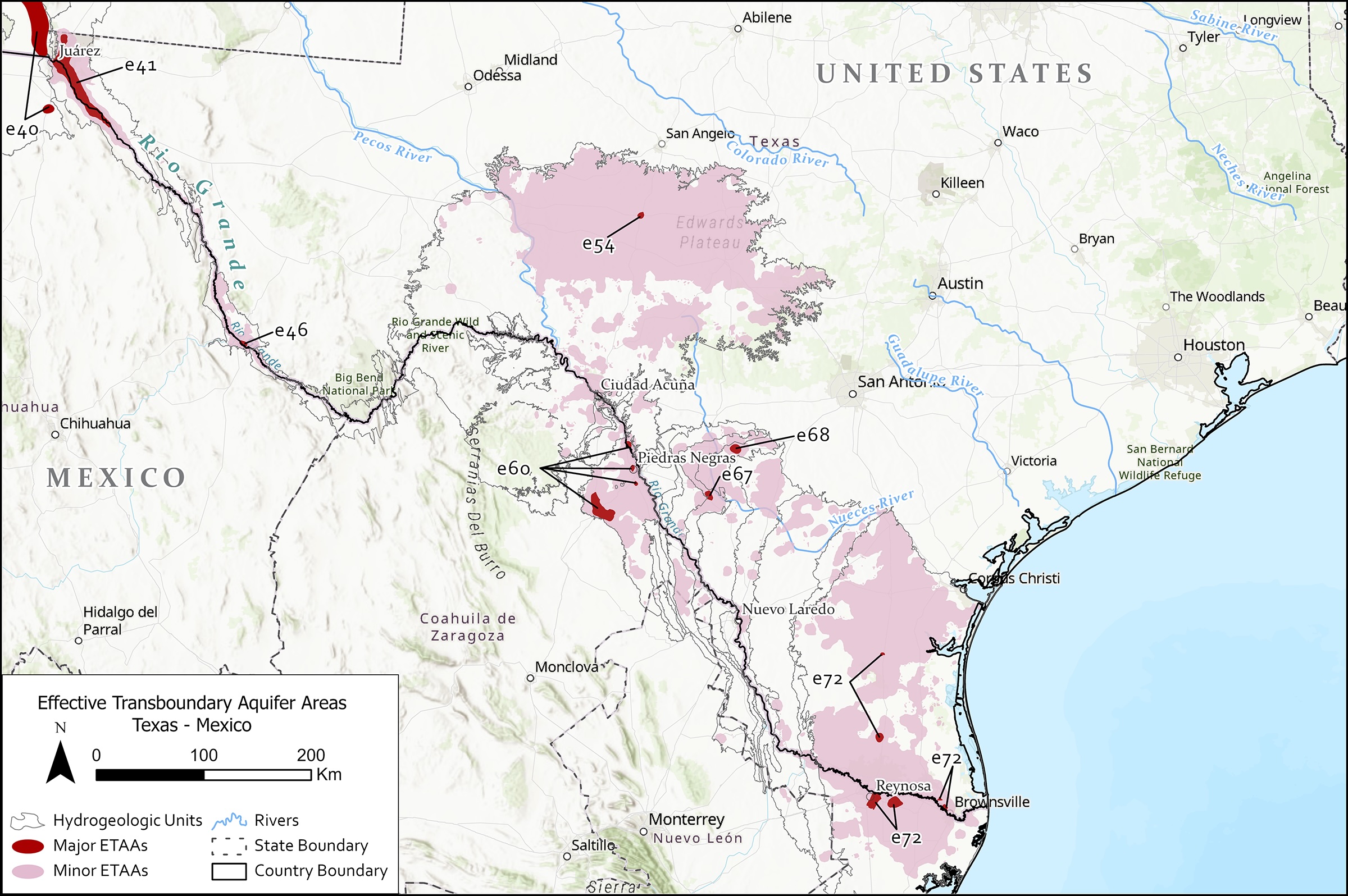
Effective Transboundary Aquifers Area (ETAA) Method
In 2024, a more robust methodology to identify priority aquifers focusing on border communities at risk due to overexploitation and groundwater dependency was published. The Effective Transboundary Aquifers Area (ETAA) approach is a method used to identify priority areas within an aquifer system. This enables a more refined and local analysis of the potential impacts of transboundary groundwater flows (Figure 2).
This method was used to identify hot spots of groundwater development — where pumping zones are concentrated — along the U.S.-Mexico border by using well density (over 99 wells per 100 square km) and depth, therefore localizing areas of priority in terms of assessment, management and monitoring. Findings of this study highlight the Mesilla Bolson aquifer as the most sensitive system in terms of well density; it has a strong surface-groundwater interaction system highly dependent on local transboundary flows. “Sensitive” here means highly susceptible to stress, depletion, and cross-border impact due to intensive use and direct reliance on adjacent surface water sources (rivers). Significant hot spots were also identified in the San Pedro and Santa Cruz TBAs (Arizona-Sonora), the Yuma/Río Colorado system (across California, Arizona, Baja California and Sonora), and the Allende-Piedras Negras (Texas-Coahuila) and the Gulf Coast/LRG Valley TBA (Texas-Tamaulipas) (Figures 3 and 4).
Figure 3 — Effective Transboundary Aquifer Areas (ETAAs): Western Map
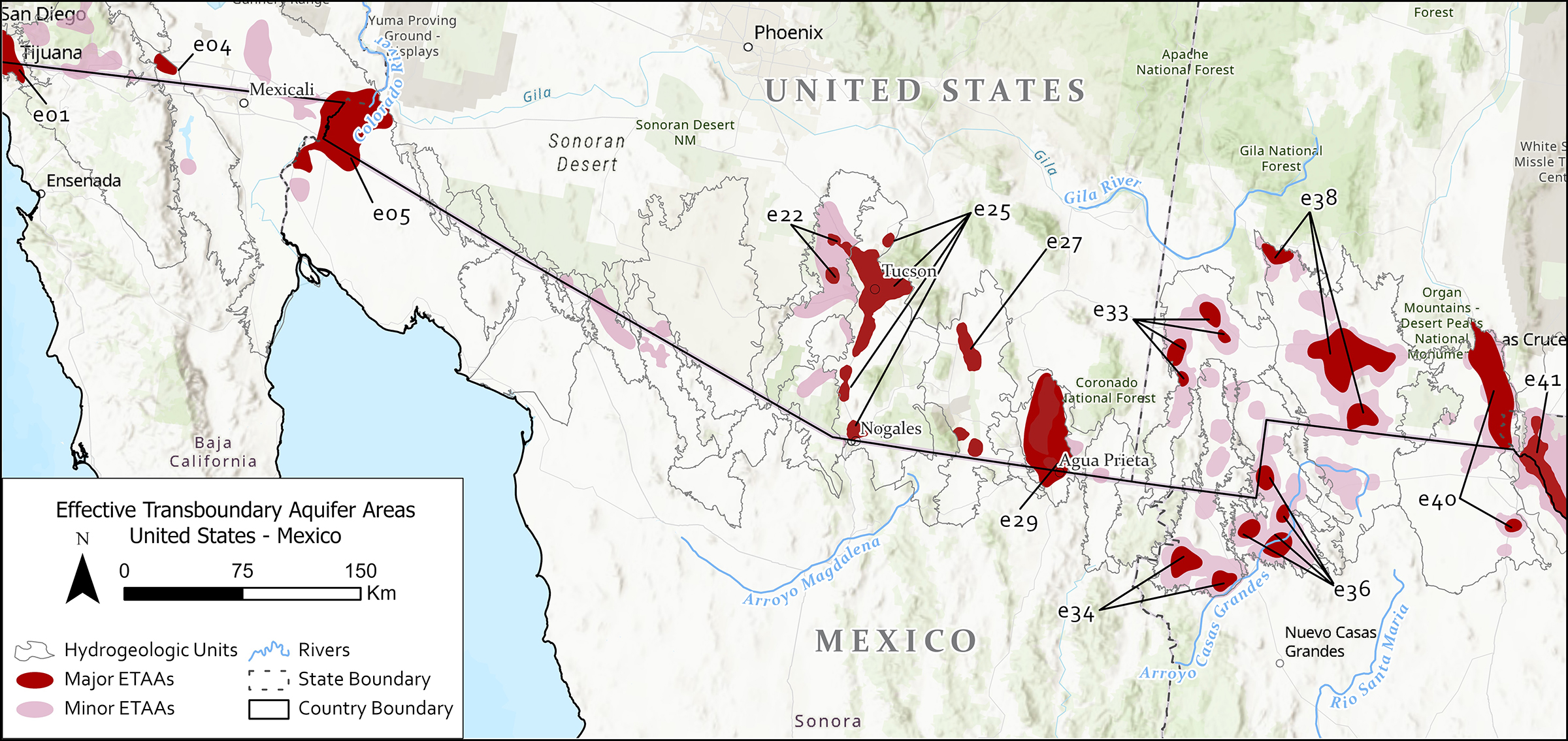
Figure 4 — Effective Transboundary Aquifer Areas (ETAAs): Eastern Map
Governance Landscape: Fragmentation and Legal Pluralism
In the U.S., groundwater governance is decentralized, operating and under each state’s distinct regulatory scheme and discretionary water authority. These varied structures include: Groundwater Conservation Districts (GCDs) as in the case of Texas, state water boards, regional planning groups, groundwater management areas, as in Arizona, and other parallel forms of management tailored to their specific water issues and local governance schemes.
Mexico has a centralized, federal system for water management, overseen by the under-resourced National Water Commission (CONAGUA). Although there is some local participation through Technical Committees for Underground Waters (COTAS) and basin councils in specific areas, the involvement of individual states or cities is very limited).
Therefore, groundwater management in the border region lacks any transboundary or even local assessment. Under the 1944 Water Treaty, binational institutions like the International Boundary and Water Commission (IBWC)/ Comisión Internacional de Límites y Aguas Entre México y Estados Unidos (CILA) (the IBWC’s Mexican section) lack explicit authority over groundwater. Despite the general exclusion of groundwater from its formal scope, IBWC minutes do contain important precedents for transboundary groundwater governance, including:
- Minute 242 (1973) — Established pumping restrictions on the Yuma/Río Colorado TBA pending a binational agreement on groundwater between the two countries.
- Minute 319 (2012) — Achieved advances in Colorado River water allocations by formally recognizing the links between surface and groundwater interactions as important elements for the restoration of the Colorado River Delta.
These examples represent a significant evolution that provides a legal and practical basis for bringing groundwater under the jurisdiction of IBWC. This development supports future amendments to the 1944 Water Treaty, which are increasingly necessary given current and future predictions of surface water scarcity in both major international basins.
Data, Tools, and Decision Support
Research and data tools concerning TBAs along the U.S.-Mexico border have developed since the mid-2000s. Important advances have been made through assessments under the Transboundary Aquifer Assessment Program (TAAP) led by the U.S. Geological Survey and the Water Resources Centers for the states of Arizona, New Mexico and Texas. TAAP originally designated four priority aquifers based on their vulnerability and the high dependency of local populations: the San Pedro and Santa Cruz aquifers (between Arizona and Sonora), and the Mesilla and Hueco Bolson (between New Mexico, Texas, and Chihuahua). The first binational study of the San Pedro TBA was released in 2016 under the IBWC coordination and a study on the Santa Cruz TBA is expected soon.
In parallel, the U.S. Geological Survey has collaborated intensively with technical binational committees to develop a Binational GeoData Center. This center aims to integrate groundwater information from both countries, making it accessible and useful for future transboundary research and development. Additionally, significant research has evolved over the last 10 years in Hueco and the Mesilla Bolson, the Allende-Piedras Negras, and some assessments on the Río Colorado/Yuma transboundary aquifers. While groundwater numerical models have been developed for a few specific aquifers, such as the Hueco Bolson and the Allende-Piedras Negras, and partial assessments exist for the Presidio, San Pedro, and Río Colorado/Yuma aquifers, very little is known of transboundary groundwater flows and impacts across most of the border region.
However, the need for more robust assessments at regional scale and on additional, non-priority aquifers is becoming critical. As surface water becomes less reliable, population and industrial growth continue to expand, and groundwater becomes more strategic as the most reliable resource, comprehensive research is needed to secure the future water supply in the border region.
Equity and Inclusion: Toward Just Groundwater Governance
Water scarcity has exposed deep inequalities in the natural distribution of water resources, the structural placement of human settlements, and the existing, often contradictory surface versus groundwater governance systems. The current status quo in the border region is an unregulated transboundary system where groundwater resources are controlled by whoever owns the well. Each country manages groundwater under its own domestic system, an approach that effectively ignores the impact on their neighbor and lacks consideration of equity or inclusion. Likewise, groundwater rights (on the U.S. side) or water concessions (on the Mexican side) do not incorporate notions of fairness across users, needs or priorities, particularly when studying current conditions or future water availability scenarios. These groundwater governance systems do not promote fair and equitable distribution because they are based on two flawed assumptions: first, that water is infinite, and second, that water can be privately used without any impact to or from neighboring users.
The tragedy of the commons is imminent for these transboundary aquifers due to the absence of effective transboundary governance. The lack of collective arrangements, clearly defined boundaries or rules tailored to regional needs has created a systemic challenge: the incentive for both sides to pump groundwater freely, resulting in the rapid depletion of this vital shared resource. Moving forward, binational cooperation on all shared natural resources (including air, surface, and groundwater) must evolve to reflect the new geopolitical and climate landscape by establishing robust institutional frameworks to overcome the current ineffective border management.
Policy Recommendations
The U.S -Mexico border region currently represents a classic, unresolved dilemma in binational commons governance. The persistent structural asymmetries in political positions regarding the environmental challenges, along with the border-centric politics of recent administrations, have effectively stalled cross-border management of these vital shared natural resources. The following recommendations propose conflict resolution mechanisms and pathways to advance transboundary aquifer (TBA) governance in the years ahead.
1. Legal Recognition and Frameworks
- Develop a binational framework agreement or treaty Minute under the 1944 Water Treaty recognizing TBAs as part of the integrated shared water systems.
- Establish protocols for data sharing, monitoring, risk management, and dispute resolution.
2. Institutional Strengthening
- Expand IBWC/CILA’s mandate to include groundwater and further climate modeling forecasting flows, droughts and desertification.
- Support capacity-building for local institutions such as COTAS, GCDs, Planning Groups, and other forms of associations at local scale.
- Evaluate the possibility of developing a case-by-case basis TBA management scheme at binational-local scale.
3. Science-Policy Integration
- Fund and develop joint hydrogeological assessments and monitoring networks, focusing initially on water quality. These initiatives could potentially be led and financed by institutions like the North American Development Bank (NADBank) and local bodies concerned with transboundary water issues.
- Develop binational technical working groups including government entities and academic centers to improve data on water issues and develop new ways to communicate scientific findings. The Permanent Forum of Binational Waters (PFBW) and the Water Observatory (under consolidation in Ciudad Juárez), are great examples of these efforts.
- Integrate decision and information-support tools directly into planning and management processes. Existing models include the initiative put forward by the Permanent Forum on Binational Waters (PFBW) to monitor water quality in the Tijuana River at a transboundary scale (“Once Coast One Community”) and the Dashboard for Environmental and Social Indicators currently being developed by the Baker Institute Center for U.S and Mexico, Monterrey Tech, and NADBank to identify risk and vulnerability.
4. Equity and Community Engagement
- Ensure representation of tribal, rural, and underserved communities, alongside participation from the public, private, academic, and nongovernmental sectors.
- Promote participatory governance and multilingual outreach, including consultation processes with border residents and stakeholders.
Sources
Callegary, James B., Ismael Minjárez Sosa, Elia María Tapia Villaseñor, et al. Binational Study of the Transboundary San Pedro Aquifer. International Boundary and Water Commission (IBWC), United States and Mexico, 2016. San_Pedro_Binational_Report_En_01122017.pdf.
Cruz, Ivonne. “US-Mexico Climate Cooperation at a Stalemate: Challenges to Air Quality.” Rice University’s Baker Institute for Public Policy, October 8, 2025. https://doi.org/10.25613/Y2CC-CY32.
Eckstein, Gabriel. “Out of Sight, Out of Mind, Out of Water.” Mexico Today, November 6, 2019. https://mexicotoday.com/2023/11/06/opinion-out-of-sight-out-of-mind-out-of-water/.
IBWC. Minute 242: Permanent and Definitive Solution to the International Problem of the Salinity of the Colorado River. 1973. https://www.ibwc.gov/wp-content/uploads/2023/05/Min242.pdf.
IBWC. Minute 319: Interim International Cooperative Measures in the Colorado River Basin through 2017 and Extension of Minute 319 Cooperative Measures to Address the Continued Effects of the April 2020 Earthquake in the Mexicali Valley, Baja California. 2012. https://www.ibwc.gov/wp-content/uploads/2012/11/Minute_319.pdf.
International Groundwater Resources Assessment Centre (IGRAC). “New Transboundary Aquifers of the World Map 2025 is Available for Download.” 2025. https://un-igrac.org/latest/news/new-transboundary-aquifers-of-the-world-map-2025-is-available-for-download/.
Megdal, Sharon B. et al. “Transboundary Aquifer Assessment Program (TAAP): Arizona Water Resources Research Center Effort.” Water Resources Research Center, University of Arizona College of Agriculture & Life Sciences Cooperative Extension. February 2023. https://wrrc.arizona.edu/sites/default/files/2023-02/Arizona-WRRC-TAAP-Five-Year-Report-Dec20-2022.pdf.
Ostrom, Elinor. Governing the Commons: The Evolution of Institutions for Collective Action. Cambridge University Press, 1990. https://doi.org/10.1017/CBO9781316423936.
Payan, Tony, and Pamela Lizette Cruz. “Redefining and Governing the Border as a Binational Commons.” Rice University’s Baker Institute for Public Policy, February 4, 2021. https://www.bakerinstitute.org/research/redefining-and-governing-border-binational-commons.
Sánchez, Rosario, and Laura Rodriguez. “Transboundary Aquifers between Mexico and the United States: The Complete Map.” Transboundariness. 2022. https://transboundariness.com/wp-content/uploads/2022/12/Transboundary-Aquifers-Challenges-and-the-way-forward-UNESCO-Rosario-Sa%CC%81nchez.pdf.
Sanchez, Rosario, Laura Rodriguez, and Cecilia Tortajada. “The Transboundariness Approach and Prioritization of Transboundary Aquifers Between Mexico and Texas.” Ambio 47 (2018): 760–70. https://dx.doi.org/10.1007/s13280-018-1015-1.
Sánchez, Rosario, Duncan Kikoyo, and Luna Yang. “Effective Transboundary Aquifer Areas Between Mexico and the United States: A Border-Wide Approach.” Journal of Hydrology: Regional Studies 56 (2024): 102003, https://doi.org/10.1016/j.ejrh.2024.102003.
Sánchez, Rosario, and Gabriel Eckstein. 2020. “Groundwater Management in the Borderlands of Mexico and Texas: The Beauty of the Unknown, the Negligence of the Present, and the Way Forward.” Water Resources Research 56, no. 3 (2020): e2019WR026068. https://doi.org/10.1029/2019WR026068.
Tracy, John C., and Michael E. Campana, eds. “Transboundary Groundwater.” Special issue, Water Resources IMPACT 20, no. 3 (2018). https://twri.agrilife.org/transboundary/wp-content/uploads/sites/41/2023/09/2018_awras_impact.pdf.
United Nations Educational, Scientific, and Cultural Organization (UNESCO). Transboundary Aquifers: Challenges and the Way Forward, edited by Rosario Sánchez. 2022. https://wrrc.arizona.edu/sites/default/files/2022-12/Transboundary_Aquifers_UNESCO_383775eng_27Nov2022.pdf.
UNESCO. “Transboundary aquifers (TBAs).” 2022. https://unesdoc.unesco.org/ark:/48223/pf0000383836.
UNESCO. “Transboundary Aquifers of the World, Update 2021.” 2022. https://unesdoc.unesco.org/ark:/48223/pf0000380193.
United States Geological Survey (USGS). “Transboundary Aquifer Assessment Program (TAAP).” Updated February 24, 2025. https://webapps.usgs.gov/taap/.
Water Utilization. 59 Stat. 1219. 1944. https://www.ibwc.gov/wp-content/uploads/2022/11/1944Treaty.pdf.
This publication was produced on behalf of Rice University’s Baker Institute for Public Policy. Wherever feasible, the material was reviewed by external experts prior to its release. Any errors are the responsibility of the author(s) alone.
This material may be quoted or reproduced without prior permission, provided appropriate credit is given to the author(s) and Rice University’s Baker Institute for Public Policy. The views expressed herein are those of the individual author(s) and do not necessarily represent the views of Rice University’s Baker Institute for Public Policy.


