
Author(s)

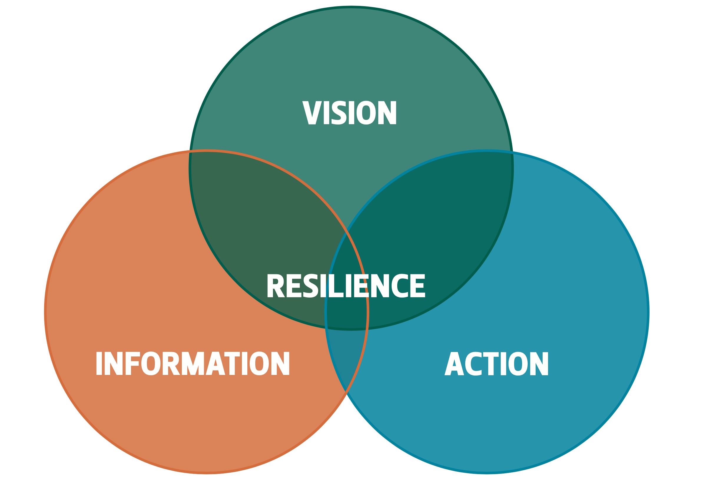
To reduce future flood damage in Houston, we need vision, excellent information, and action. When these three elements are combined, we will have a solid, functional plan. Without all three elements, we will fall short of the Houston that all of the city’s residents want and deserve.1
Vision
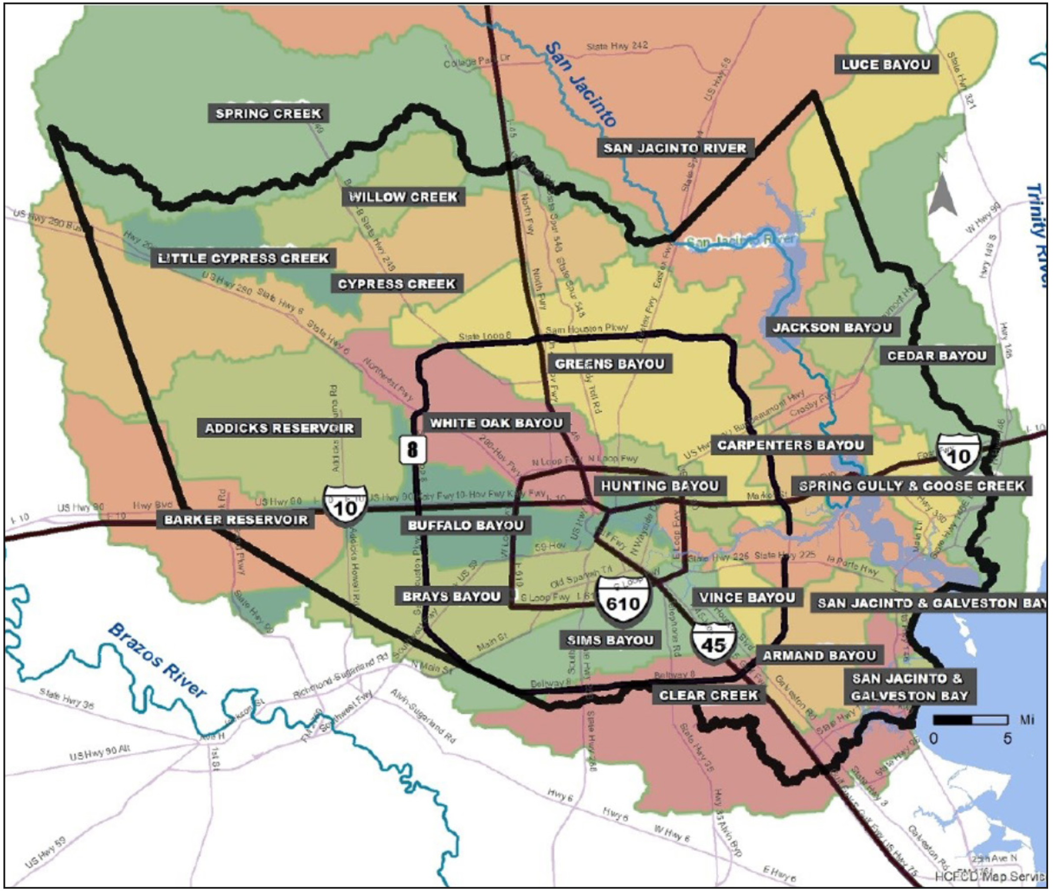
We would all like to see a Houston and a Harris County that do not flood. Realistically, that is not going to happen. Houston/ Harris County is made up of 23 watersheds that serve as drainage areas for various creeks, bayous, and one major river—the San Jacinto. During and after a rain, these bayous and creeks rise and fall quickly. They have always flooded, and will continue to do so in the future. Despite major physical improvements made to channels and drainage ditches throughout the area, Houston will not be able to contain the overflow from heavy rainfall events such as Tropical Storm Allison, Hurricane Harvey, or the Tax Day floods within these stream and creek channels. It is just not going to happen.
First, residents and local leaders must realize that our rainfall events are getting larger. For decades, the level of rainfall classified as the 100-year-storm (which has a 1% chance of occurring in any given year) was believed to be 13 inches of rain in 24 hours, but the Greater Houston area has exceeded that several times. “Atlas 14,” a new study published by the National Oceanic and Atmospheric Administration (NOAA), increased the 100-year-storm parameters for much of Harris County to 17 inches of rain in 24 hours—a 31% increase in rainfall—but that only covers present-day weather and climate conditions. All evidence indicates that the storms of the future will be even more intense, further increasing the expected rainfall levels for extreme rain events beyond what they are currently projected to be from the standpoint of the present. Dramatically increased rainfall is one aspect of our changing climate (which is indeed changing). These dangerously intensified rains are real. The first component of our vision involves recognizing the changes that are coming and anticipating them. Otherwise, our planning efforts will be misguided.
Figure 1 — A Plan for Harris County/Houston Flood Damage Reduction
Second, we must envision living with this increased rainfall. This water cannot be completely banished to underground pipes and bigger channels. There is simply not enough money or time. Instead, the water needs land over which it can flow when the big rains come. We cannot control storms like Harvey or Allison, but we can manage them, and we can live with them. However, we need to make room for the water, and that means moving as many homes and people out of harm’s way as possible. First, we need to study the current plans to improve the drainage of each of our bayous. Then we need to conduct computer modeling that, at the very least, conforms to the levels of the NOAA “Atlas 14” rain events and determine how much land would remain subject to flooding when the drainage improvements have been completed. We should then explain this situation to homeowners and neighborhoods and make reasonable offers to buy out those homes that are subject to the highest levels of flooding. While this course of action may not be popular, it will work to reduce flood damage. This is what it means to live with water.
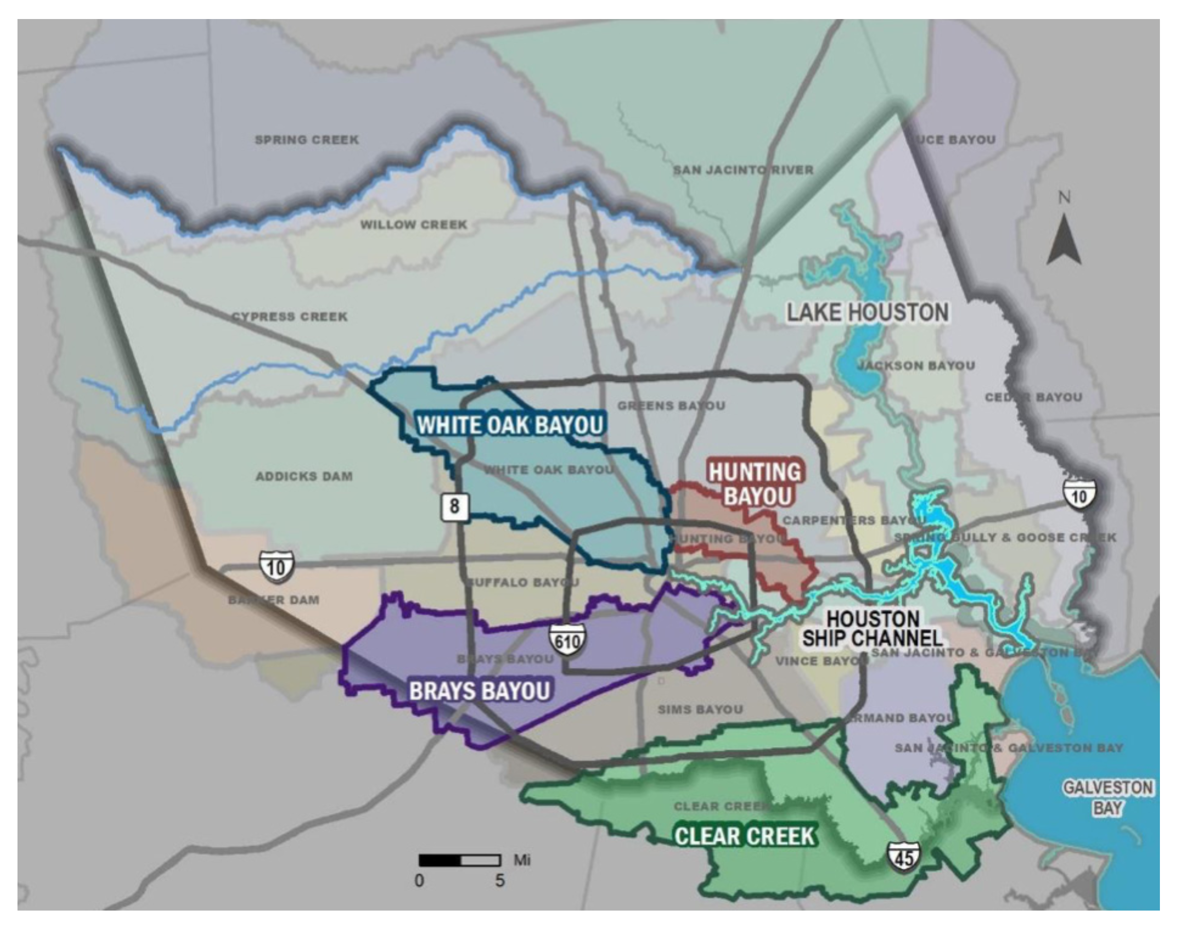
Figure 2 — Harris County Watersheds
Third, we need to have a transparent and equitable management system. Members of the public must feel that they are partners in this effort to live with flooding. Too often, citizens learn about decisions after they have been made. Too often, our lower income areas seem to be disproportionately harmed by flooding. These issues must be addressed openly and directly. The framework documents for the recently passed $2.5 billion Harris County flood infrastructure bond included mandatory public participation and a legally enforceable requirement mandating geographic equity in the expenditure of the bond funds. We need to build on this strong base established by the county in 2018; it sets a great precedent for all levels of government.
Information
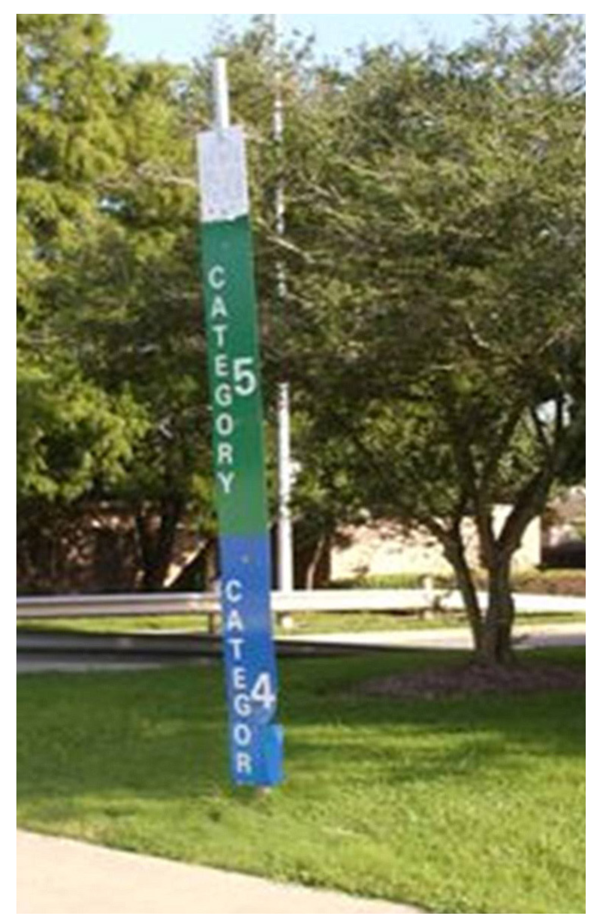
To reduce damage from floods in Houston, we must provide high-quality information to the public. For too many years, we have failed to help residents understand the true flood risks posed by hurricanes and major rain events. For instance, a sign in the Clear Lake area indicating how high surge waters would rise in the event of a Category 4 or 5 hurricane was removed because it interfered with home sales. We must be more concerned about protecting our citizens than selling homes, period.
Even before Harvey made landfall, the U.S. Army Corps of Engineers predicted that there would be extensive flooding behind the Addicks and Barker reservoirs. These projections became more and more specific as the storm progressed from Thursday, when Harvey was still in the Gulf, into Sunday, when many Houston-area homes flooded. Residents living in the flood pool behind the Addicks and Barker reservoirs could have been given at least a 24-hour warning that they were likely to be flooded Sunday night or Monday morning. Similarly, the Corps projected that water from the reservoirs would need to be released downstream well before the release occurred. In short, crucial information was available, but it was not delivered to those who needed it most. That needs to change, but in order to facilitate such a shift, local leaders need to be willing to share the hard truths and trust residents to respond intelligently.
Figure 3 — Flood Marker Removed in the Clear Lakes Area Over Real Estate Sales Concerns
After being flooded by Tropical Storm Allison, officials in the Texas Medical Center decided to take matters into their own hands and learn to “live with flooding.” To this end, hospitals hired a consultant to develop a system of flood-proof gates to protect their basements and parking areas and develop a flood warning system to alert them when the Brays Bayou was threatening to flood the medical center. This system was developed by Phil Bedient at Rice University’s Severe Storm Prediction, Education, and Evacuation from Disasters (SSPEED) Center, and it tracks rainfall accumulations and real-time radar imagery, monitors bayou flood gauges, and uses computer modeling to predict if and when the medical center must move into “floodproof mode.” When the signal is activated, hospital leaders close the flood gates and inform all personnel at work to remain on duty at their facilities. Similarly, those scheduled to come into work are called and told not to come. The medical center made it through Harvey without any serious flood damage issues.
Likewise, a warning system should be created for each creek, bayou, and river in Harris County. As alerts go into effect, information should be disseminated across several different avenues, including TV and radio channels, the internet, and perhaps even through trucks with loudspeakers. Residents need to be warned if flooding is imminent. We can survive what we know and understand. Similarly, warnings about flooded roads and underpasses should be widely shared. Our streets are our secondary drainage system—they are designed to flood. But often, residents don’t know how to navigate unfamiliar parts of town to evacuate when a storm event occurs. We should have information and tools to help us drive more safely during heavy rains, such as a downloadable app that navigates us toward the safest routes.
Finally, we must ensure that no one buys or rents a home in a hurricane evacuation zone without being notified of that fact. Residents who move to the Houston area from regions where hurricanes are not common could easily purchase a home in an evacuation zone without knowing the risk the location poses. We also need to distribute a “surviving flooding” information kit for new (and old) residents.
The bottom line is, we need first-class information to live with and survive the storms that Houston is sure to experience in the future. Providing information is inexpensive, but disclosing potentially negative information defies our traditions. Our past should not be allowed to dictate our future. If it does, we will fail. We must embrace technology and use it wisely in order to move forward in a positive direction in the 21st century.
Figure 4 — Hurricane Evacuation Zones in the Houston-Galveston-Matagordon Region of the Upper Texas Coast
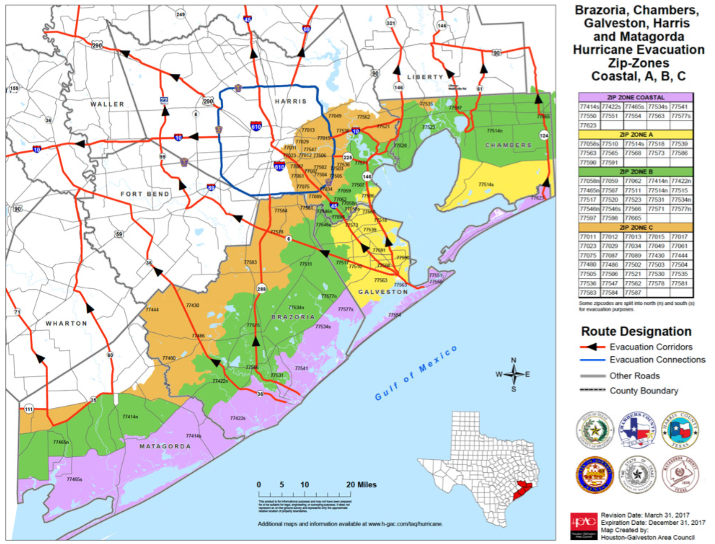
Figure 5 — Harris County Action Zones
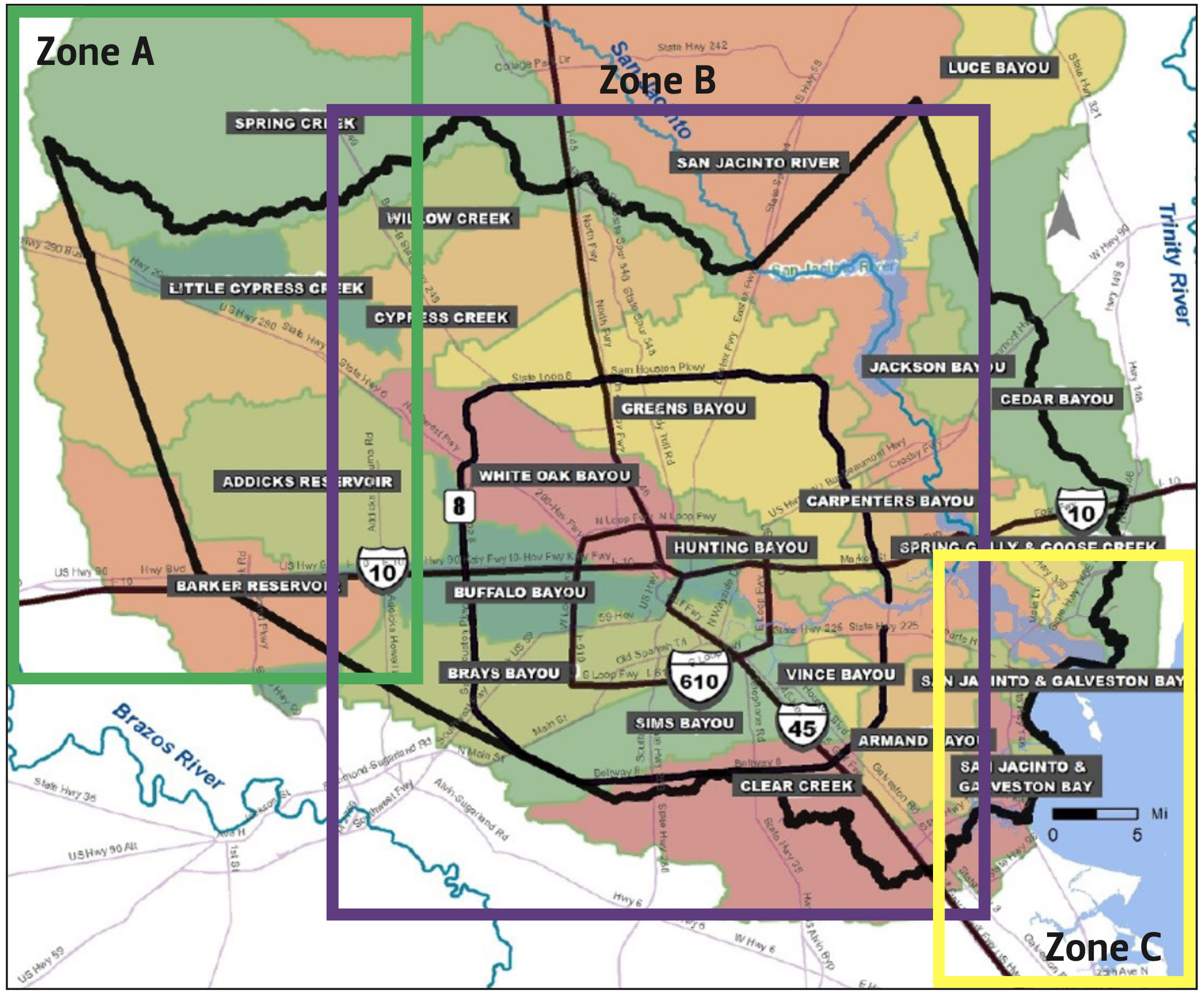
Notes Zone A is the western segment of the county and includes undeveloped land in the Katy Prairie region as well as the Addicks and Barker reservoirs. Zone B is the developed heartland of Harris County and includes most of the major watersheds. Zone C includes Galveston Bay, the Houston Ship Channel, and the low-lying portions of eastern Harris County.
Action
There are many specific actions that need to be taken to improve our current situation. Some are already underway. Others need to be designed. Yet these actions need to be guided by a strong vision and combined with information in order to truly change the situation in Houston and Harris County. For the purpose of providing clarity in this section, Harris County is divided into three areas—A, B, and C—as shown in Figure 5. Zone A is the western segment of the county and includes undeveloped land in the Katy Prairie region as well as the Addicks and Barker reservoirs. Zone B is the developed heartland of Harris County and includes most of the major watersheds. Zone C includes Galveston Bay, the Houston Ship Channel, and the low-lying portions of eastern Harris County. All of these areas must be included for our plan to be effective.
Zone A
Zone A encompasses the Katy Prairie and Addicks and Barker reservoirs. Addicks and Barker are two of the best flood control investments Harris County has made, but they have been allowed to fall into disrepair and must be fixed as soon as possible. These reservoirs have been evaluated by the Corps of Engineers as two of the six most dangerous reservoirs in the U.S., based on the potential risk of levee failure and the consequences of such failure. This has been known for at least 10 years, yet has not been addressed. Further, several short-term steps can be taken to improve the storage capacity of these reservoirs, such as excavating silt accumulated over the course of their nearly 70 years of operation. The Army Corps of Engineers must prioritize these actions and also find a solution for the 10,000-plus homeowners who live near and were flooded by the flood pool of these two dams during Harvey. Such home development should not have been permitted, but it was. We must now address these past omissions.
Zone A also includes the best natural sponge in our region—the Katy Prairie. Native prairie has an amazing ability to store water. Its deep root systems penetrate clay soil and allow rainfall to move into the soil. Further, the flat terrain, with numerous depressions, can store billions of gallons of water. The Katy Prairie Conservancy has been trying to preserve these lands for decades. Their efforts need to be supported by local, state, and federal authorities. Undeveloped prairie lands remain and can be restored. In addition, we should explore paying landowners who wish to continue ranching in the area to build small berms and impound water on their land. We could pay landowners $100 per acre across 50,000 acres and store more floodwater more cheaply than we could with a 5,000-acre reservoir. These actions should be pursued.
Zone B
Zone B is the developed heartland of Harris County. Four federal projects have recently been funded, and the recently passed Harris County bond issue secured the local match for these efforts. These projects are located on the Brays, White Oak, and Hunting bayous and on Clear Creek and are moving toward implementation. As part of the bond election, the county held meetings in the various watersheds and committed to undertake projects on the other watersheds not covered by federal projects. Initial work has been authorized and the design process is underway for dozens of such projects throughout the county. However, while these efforts will improve flow conditions, they will not prevent floodwaters from leaving the banks and flooding adjacent lands. Each of these watersheds must have a buyout program along with channel improvements and new retention and detention pond construction.
Figure 6 — Watershed Designated to Receive Federal Funding
Various watersheds within Zone B have unique problems. In the past, on bayous such as Brays, drainage regulations were not effective in preventing upstream development from increasing downstream flooding. Although many of the region’s watersheds today are almost fully developed, several such as the Spring Creek, Cypress Creek, Addicks, and Barker reservoirs and Sims Bayou have significant remaining undeveloped land. Strong runoff requirements are needed to ensure that the upstream concrete and drainage ditches in these areas do not further worsen downstream flooding. In the Kingwood and Atascocita areas, which are located along the San Jacinto River and Lake Houston, siltation of the river channel leading into the lake has emerged as a major problem. We need to better understand the source of that silt and control it. And we must always be mindful that lower income watersheds such as the Hunting, Greens, Halls, and Sims bayous were among the most heavily impacted during Harvey. We must not allow inequity in our spending.
Zone C
Zone C includes the low-lying eastern shoreline of Harris County, the Houston Ship Channel, and the Bayport Industrial District. In this area, hurricane surge is the worstcase flooding scenario. This portion of Harris County is extremely vulnerable to massive damage from storm surge, which is projected to reach 25 feet in elevation. This surge is violent and destructive—very different than standard rainfall flooding. Such a surge would destroy the industrial community, flooding upwards of 2,200 storage tanks and releasing an estimated 90 million gallons of oil and hazardous substances. Not only would this storm surge event cause many to lose their lives, it would decimate the local economy, harm the national economy, and destroy the ecology of Galveston Bay.
Figure 7 — The Galveston Bay Park Plan
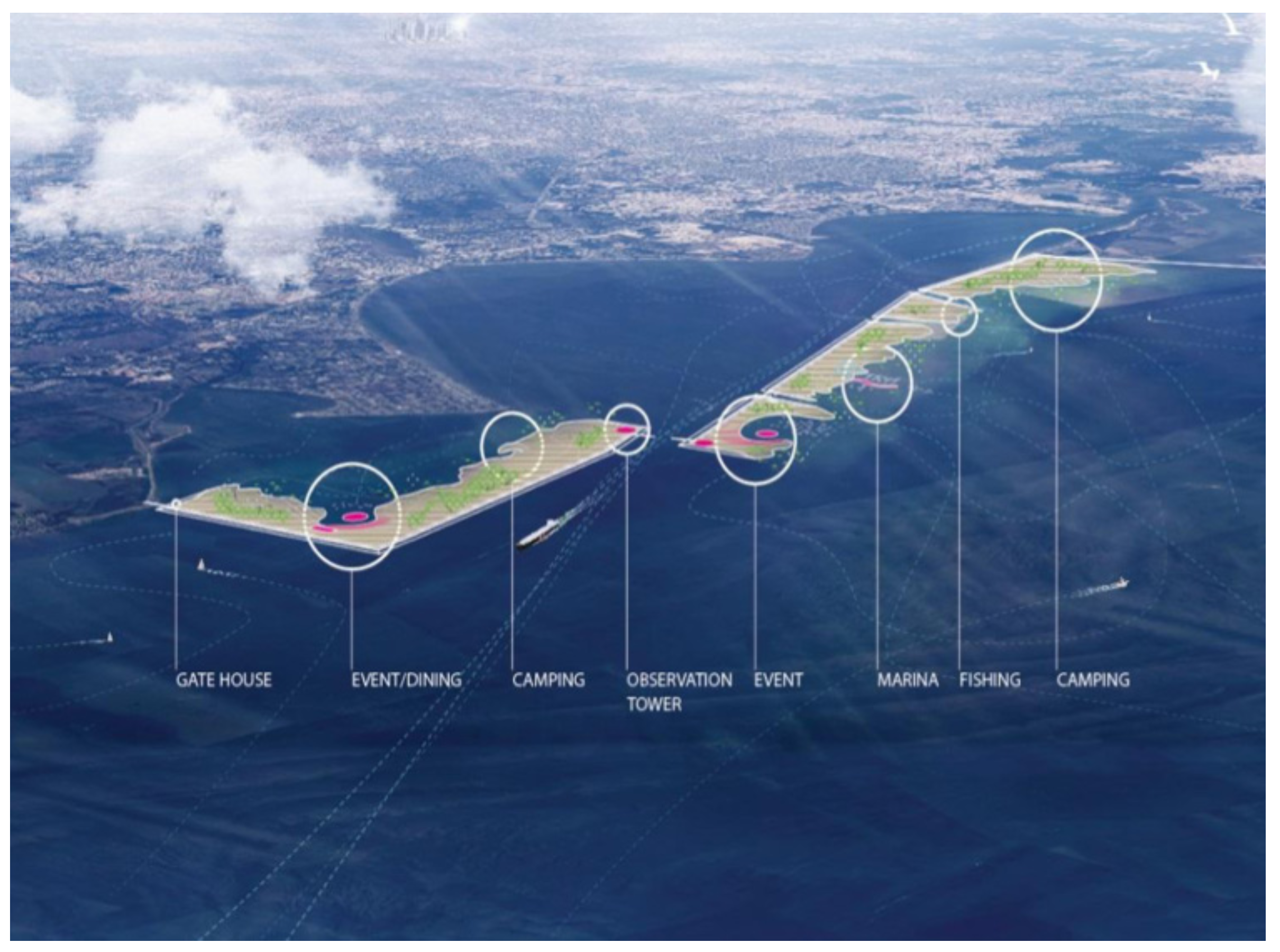
To date, efforts to address this issue have been slow to emerge. The Army Corps of Engineers recently released a study on a massive dike complex along the coast that is projected to cost upwards of $30 billion and would not be constructed until about 2035, assuming approval of final environmental impact documents in 2021. Harris County cannot and should not wait that long. A supplement to the larger coastal dike called the Galveston Bay Park Plan can create protection for the industrial base and the developed Harris and Galveston County shoreline of Galveston Bay for about $3 billion. Harris County should obtain a permit to construct this plan so that we will have the option of building our own defense. This project could be permitted within a few years and constructed in three to five, meaning that it could be completed by 2025. Structures that would be subsequently added by the Corps of Engineers will simply make the defenses stronger.
Conclusion
The Houston Plan for Flood Damage Reduction is both realistic and achievable. We just need to do it.
Endnotes
1. This plan is derived from a Baker Institute paper “Houston a Year after Harvey: Where We Are and Where We Need to Be.” See https://www.bakerinstitute.org/research/houston-year-after-harvey-where-we-are-and-where-we-need-be/.
This material may be quoted or reproduced without prior permission, provided appropriate credit is given to the author and Rice University’s Baker Institute for Public Policy. The views expressed herein are those of the individual author(s), and do not necessarily represent the views of Rice University’s Baker Institute for Public Policy.


