
To access the full paper, download the PDF on the left-hand sidebar.
Introduction
When Hurricane Ike hit the Texas coast in 2008, the Greater Houston region dodged a bullet. To be sure, there was massive destruction to the east on the Bolivar Peninsula, to the south in Galveston, and to Galveston Bay communities such as Bacliff and Shoreacres. However, the bulk of our region escaped major damage thanks to the last-minute jog in Ike’s path that took it up the middle of Galveston Bay, sending the worst surge into the wetlands and coastal prairies of Chambers and Jefferson counties, as shown in Figure 1.
Figure 1 — Hurricane Ike Inundation Depth
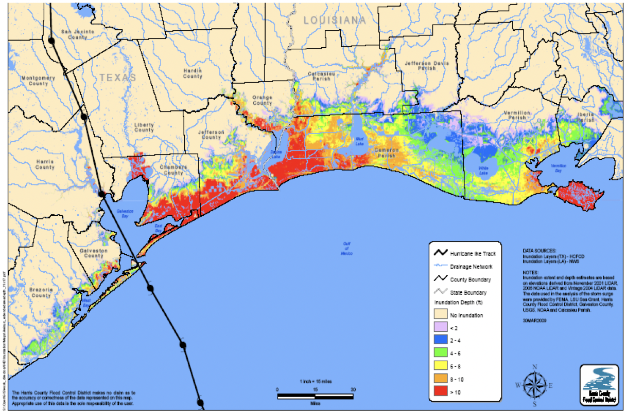
Note The areas flooded by Hurricane Ike extended far to the east of Galveston Bay, inundating coastal lands 15-20 miles inland.
After Ike, the Severe Storm Prevention, Education, and Evacuation from Disaster (SSPEED) Center at Rice University was funded by the Houston Endowment to study and learn from Hurricane Ike and to propose solutions to reduce damage in the future. Over the intervening 10 years, much has been learned about reducing damage from hurricane surge. Perhaps more importantly, these new approaches do not simply address hurricane surge. They also produce economic benefits locally, enhance quality of life, support ecosystem integrity, rejuvenate the rural economy, and address sea level rise. These projects also offer customizable and adaptable models for coastal communities across the U.S. to address challenges presented by sea level rise and stronger and more frequent storms.
One early realization about Ike that strongly influenced the SSPEED Center’s work was that the hundreds of thousands of acres of open space inundated by saltwater surge, as far as 20 miles inland, recovered relatively quickly, at little cost to the taxpayer and with no reported loss of human life. It offered a stark contrast with the devastation—human, social, and economic—experienced on the Bolivar Peninsula and in Galveston, Bacliff, Shoreacres, and elsewhere. Based on this observation, the SSPEED Center team pursued strategies that would incentivize keeping marshes, coastal prairies and coastal bottomlands in their natural state so that the impact of future surges could be accommodated with minimal damage. In short, strategies for keeping coastal open spaces open were designed and are in the process of being implemented.
Another realization from Ike was that if its path had been slightly further south, and the worst of the surge had gone up toward the Houston Ship Channel, several hundred thousand residents would have been at risk, countless lives would have been lost, and Galveston Bay would have been home to an ecological disaster the likes of which the U.S. has not previously seen. Additionally, the impact to the industrial complex responsible for 25% of Texas’ GDP and 20% of the U.S. refining capacity would have resulted in massive economic losses. So strategies for structural alternatives to protect the 2.2 million barrels of refining capacity, the several hundred petrochemical plants, and the 800,000 people living on the developed west side of Galveston Bay were also pursued.
These early realizations shaped proposals that integrate economic development and nature to address our region’s flood problems, along with structural solutions that serve multiple purposes. Further, these projects not only reduce damage from flooding, they also generate and reinforce other key aspects of long-term coastal resilience such as producing local and regional economic benefits, ecosystem integrity, enhanced quality of life, and rural economic rejuvenation. They are in various stages of implementation and include the proposed Lone Star Coastal National Recreation Area (LSCNRA), the Texas Coastal Exchange (TCX), and the Galveston Bay Park Plan (GBPP). Taken together along with the ongoing work of the U.S. Army Corps of Engineers (USACE) and the Texas General Land Office, these projects offer a vision for a vibrant and resilient future for the upper Texas Gulf Coast, whatever the weather may bring.
In the sections that follow, these structural and nonstructural concepts are presented. First, the nonstructural alternatives—the proposed Lone Star Coastal National Recreation Area and the Texas Coastal Exchange—are set out, with their focus on creating economic benefits around nature. Then, the structural alternative—the Galveston Bay Park Plan, which combines flood protection and industrial navigation expansion with environmental enhancement, recreation, and an outstanding quality of life amenity—is discussed, as is the USACE’s plan for the coastal barrier and coastal restoration.
This material may be quoted or reproduced without prior permission, provided appropriate credit is given to the author and Rice University’s Baker Institute for Public Policy. The views expressed herein are those of the individual author(s), and do not necessarily represent the views of Rice University’s Baker Institute for Public Policy.


